Maps on Data Queensland
The Department of Natural Resources and Mines has made available a collection of digitised maps over Queensland at various scales 1841–2005, including cadastral maps which show property boundaries, property descriptions and land tenure, and some other related miscellaneous maps.
They can be downloaded from the Data Queensland website
A pdf version of Bob's presentation on accessing and using these maps can be viewed from here.
They can be downloaded from the Data Queensland website
A pdf version of Bob's presentation on accessing and using these maps can be viewed from here.

Pastoral Districts
Looking for a large pastoral run or holding? Check this index map showing the extent of each of the Pastoral Districts and the coverage of the 2-mile and 4-mile series of maps showing them. Parishes
Several small (approx 25 sq mi) parishes together make up a county. Refer to the DNRME Place Names Database, search for a name, filter the result by Parish and click the image link to see a map. Or download the Historical Parish Directory (in 4 pdf parts). |

Land Agent's Districts
These were the administrative units responsible for managing smaller leases. You can use this map to identify the specific maps (2 mi or 4 mi) covering your area of interest. 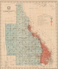
Counties
Use this index map to identify the location pf a copunty of interest and select the most appropriate maps from the 2- mile and 4-mile series to cover it. |
