Finding places - Maps
Perhaps more than any other area of the world, German genealogy depends on having good information on where your ancestors lived. Most records have not moved very far from where they were created.
Using German maps and atlases confidently will play a vital part in determining your success. However, you should also become familiar with the complementary tool - the Gazetteer.
Using German maps and atlases confidently will play a vital part in determining your success. However, you should also become familiar with the complementary tool - the Gazetteer.
As is the case in Australia, you will probably turn first to Google Maps for an overview of the modern country. Of course there are many other suppliers of online maps; just search for german maps then click on images.
NationsOnLine gives you a searchable map of Germany based upon Google Earth data. One advantage of this search box is that you will immediately see just how many places there are with the name you are searching for.
The IEG is the Institute for European History and it offers a comprehensive collection of maps of different ages (1300-2000). You can use these to view the shifting borders that might have driven your ancestors to leave or the spread of the networks of roads and rail that might have assisted them to do so.
One family site, called Posselt Ancestry has assembled an amazing collection of historical Landkarten (maps) at http://www.posselt-landkarten.de/ spaning much of 19th century Europe. These are very high resolution maps that can be zoomed to show amazing detail.
The worldwide David Rumsey Map Collection also includes similar detail in its map of the empire in 1893, http://www.davidrumsey.com/blog/2011/4/10/karte-des-deutschen-reiches-1893
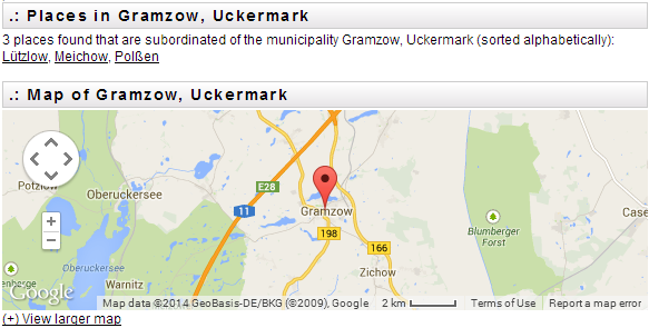
The website Places in Germany allows you to narrow your search for a detailed map by working your way through a hierarchy of nested geographical and administrative units. For example selecting the Federal State of Brandenburg, then the District of Uckermark, then the Municipality of Gramzow leads to this map from which you can then zoom in or out, or switch to a larger map centred on Gramzow.
NationsOnLine gives you a searchable map of Germany based upon Google Earth data. One advantage of this search box is that you will immediately see just how many places there are with the name you are searching for.
The IEG is the Institute for European History and it offers a comprehensive collection of maps of different ages (1300-2000). You can use these to view the shifting borders that might have driven your ancestors to leave or the spread of the networks of roads and rail that might have assisted them to do so.
One family site, called Posselt Ancestry has assembled an amazing collection of historical Landkarten (maps) at http://www.posselt-landkarten.de/ spaning much of 19th century Europe. These are very high resolution maps that can be zoomed to show amazing detail.
The worldwide David Rumsey Map Collection also includes similar detail in its map of the empire in 1893, http://www.davidrumsey.com/blog/2011/4/10/karte-des-deutschen-reiches-1893
The website Places in Germany allows you to narrow your search for a detailed map by working your way through a hierarchy of nested geographical and administrative units. For example selecting the Federal State of Brandenburg, then the District of Uckermark, then the Municipality of Gramzow leads to this map from which you can then zoom in or out, or switch to a larger map centred on Gramzow.